Map Portlet Options
Available options depend on the type of map and other factors.
Map portlets use GeoJSON format files (which are bundled inside diveport.war). Additional information can be found in the webapps Map Portlet folder. If you have existing map files in a different format, you can use a utility such as ogr2ogr to convert the original shapefiles to GeoJSON format. Place the new file in the Solution\webdata\diveport\customizations\map-data folder. For more information, see Converting a shapefile to GeoJSON format.pdf or contact DI support.
| Option | Description | ||||||||||||||
|---|---|---|---|---|---|---|---|---|---|---|---|---|---|---|---|
| Street Layer | Defines the map base layer. The default Automatic, uses Other options are: None Renders the map without a street layer. NOTE: The use of Thunderforest base layers requires a Thunderforest API key to be defined in the Portal Settings dialog box. See DivePort Portal-Level Settings. |
||||||||||||||
| Add a layer |
Opens the Select a layer type dialog box, which you can use to select the type of map that you want to use. Options are Boundary, Heat, Line, Point, and Web Map Service. TIP: You can create a multi-layer map. This |
||||||||||||||
| Select a data source page | |||||||||||||||
| Project | Specifies the Workbench Project that you are using. | ||||||||||||||
| Look in | Specifies the project folder where the marker is saved. | ||||||||||||||
|
|
Moves the browse sequence up one level. | ||||||||||||||
| File name | Specifies the Spectre Dive, cBase, cPlan, Marker, or DiveBook source file to be used for map data. | ||||||||||||||
| Files of type | Specifies the type of files that appear in the data source list on this page. You can select a type to filter the data source list. | ||||||||||||||
|
Select Line ID page Applies to line maps. This page lists available values from the selected Spectre Dive, cBase, cPlan, Marker, or DiveBook. Double-click the value that contains descriptive labels that display in a tooltip that appears when you place your pointer on the line. |
|||||||||||||||
|
Select a location value page This page lists available values from the selected Spectre Dive, cBase, cPlan, Marker, or DiveBook. Select the type of location value:
And then double-click the value that you want to use. |
|||||||||||||||
| Select a source location/Select a target location pages Applies to line maps. This page lists available values from the selected Spectre Dive, cBase, cPlan, Marker, or DiveBook. Double-click the value that contains geographical formatted longitude/latitude data to define the source (origin) and target (destination) points for the line. |
|||||||||||||||
|
|
Opens a context menu that you can use to sort the lists on this page. Options are Sort by type and Sort by name. | ||||||||||||||
|
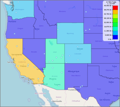
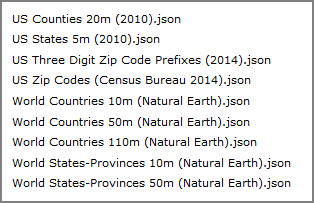
Select a geometry source page Applies to boundary maps only. This page lists available geometry sources. Double-click the value that aligns with the selected location value. The World States-Provinces 50m (Natural Earth).json is limited to US and Canada maps. However, the World States-Provinces 10m, World Countries 10m, World Countries 50m, and World Countries 110m json files contain data for all countries. TIP: If you are migrating a portal from DivePort 6.4 or earlier that uses an older 3-digit zip code map, you might need to edit the portlet to update the geometry source and location key. |
|||||||||||||||
|
Select a location key page Applies to boundary maps only. Specifies the format of the geographical data in the source data file. For example, if you are mapping the data by county, the location key could be County Code or County Name. You must enter the same location key that is used in the Spectre Dive, cBase, cPlan, Marker, or DiveBook. NOTE: The values in the geographical dimension must use the same format as the geometry source. These values are case-sensitive. For example, the US Counties source that is included with DivePort uses the format <County,ST> where County is the county name, and ST is the two-letter state abbreviation. |
|||||||||||||||
|
Select a value page This page lists available dimensions from the selected Spectre Dive, cBase, cPlan, Marker, or DiveBook. Double-click the data value that you want to use. |
|||||||||||||||
|
Layer Settings page This page summarizes the selections that were made for the map portlet. |
|||||||||||||||
| Source | Specifies the source file. | ||||||||||||||
|
|
Opens the Select a data source page, which you can use to browse to a different source file. | ||||||||||||||
|
|
Opens a context menu where you can select an application in which to display the selected source data file. | ||||||||||||||
| Type | Specifies the map type that was selected on the Select a layer type page. | ||||||||||||||
| Name | Specifies a label for the map legend. | ||||||||||||||
| Line ID | Applies to line maps. Specifies the dimension that was selected on the Select Line ID page. Click the chevron if you want to change the value. | ||||||||||||||
| Source Location | Applies to line maps. Specifies the dimension that was selected on the Select a Source Location page. Click the chevron if you want to change the value. | ||||||||||||||
| Target Location | Applies to line maps. Specifies the dimension that was selected on the Select a Target Location page. Click the chevron if you want to change the value. | ||||||||||||||
| Location | Specifies the dimension that was selected on the Select a location value page. Click the chevron if you want to change the value. | ||||||||||||||
| Location ID | Applies to maps that specify separate latitude and longitude columns. Identifies the location for click actions. | ||||||||||||||
| Latitude | Applies to maps that specify separate latitude and longitude columns. Defines the latitude coordinate. | ||||||||||||||
| Longitude | Applies to maps that specify separate latitude and longitude columns. Defines the longitude coordinate. | ||||||||||||||
| Value | Specifies the dimension for map data that was selected on the Select a value page. Click the chevron if you want to change the value. | ||||||||||||||
| Auxiliary Measure Value | Specifies a baseline or goal value that is defined in the Measure Factory. | ||||||||||||||
|
|
Available Opens the time series mode settings box. Options are Basic and Advanced. |
||||||||||||||
| Basic time series settings |
Basic features are as follows:
|
||||||||||||||
|
Advanced time series settings |
Advanced features allow the following customization of the time period:
|
||||||||||||||
| Boundary map options | |||||||||||||||
| Geometry Source | Applies to boundary maps. Specifies the json file that was selected on the Select a geometry source page. Click the chevron if you want to change the value. | ||||||||||||||
| Location Key | Applies to boundary maps. Specifies the location key that was selected on the Select a location key page. Click the chevron if you want to change the value. | ||||||||||||||
| Point map options | |||||||||||||||
| Cluster points with descriptor | Applies to point maps only. Combines data points into a cluster, and provides a text box that you can use to specify a custom tooltip for the cluster of points. | ||||||||||||||
| Shape | Applies to point maps. Specifies the shape of the data points. The default is Triangle. Other options are Circle, Square, and Icon. | ||||||||||||||
| Icon Source |
Applies to point maps using an Icon shape. Specifies a custom icon that located in the \webdata\<diveport>\doc-libraries\Portal Media\images folder. NOTE: On the map, icons assume the size of the source image. |
||||||||||||||
| Heat map options | |||||||||||||||
| Radius | Applies to heat maps. Specifies the radius, in pixels, of each data point. | ||||||||||||||
| Blur | Applies to heat maps. Specifies the blur factor, in pixels, that is applied to the data points. Higher blur factors produce smoother gradients. | ||||||||||||||
| Line map options | |||||||||||||||
| Shape | Applies to line maps. Specifies if the line is Strait or Curved. If Curved is selected, you can specify the angle of the curve by degrees in the range of -45 to 45. Setting 0 degrees draws a straight line. | ||||||||||||||
| Thickness | Applies to line maps. Specifies the line thickness, in pixels. | ||||||||||||||
| Point Shape | Applies to line maps. Specifies the shape of the source and target data points. The default is Triangle. Other options are Circle and Square. | ||||||||||||||
| Point size |
Applies to line maps. Specifies the size, in pixels, of the source and target data points. |
||||||||||||||
| Web Map Service options | |||||||||||||||
| URL |
Applies to Web Map Service maps. Specifies the URL of the Web Map Service. For example, https://idpgis.ncep.noaa.gov/arcgis/services/NWS_Forecasts_Guidance_Warnings/NDFD_temp/MapServer/WMSSever? Note the following:
|
||||||||||||||
| WMS Layer Name | Applies to Web Map Service maps. Specifies the name of the WMS layer. | ||||||||||||||
 ,
,
More settings
The Street Layer page has links to More settings at the bottom of the page. These options affect the map base layer.
TIP: You can use both Position and Extent to constrain latitudes and longtitudes—this locks the map so it can only scroll up and down. If you want full drag capability, do not use these attributes at the same time.\
You can use ![]() Position settings to specify the initial map view.
Position settings to specify the initial map view.
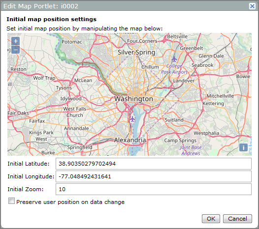
- Click the map on the Initial map position dialog box and use a drag operation to move the map until it shows the area that you want to display. The Initial Latitude and Initial Longitude boxes adjust accordingly to identify the center of the map.
- On the upper left corner of the map, press + or – to zoom in or out. Alternatively, you can enter an integer in the Initial Zoom box. Higher zoom levels show higher resolution and a smaller area. Zoom level 0 shows a view of the Earth.
- Preserve user position of data change If a user changes the map position or zoom level, this option retains the user-selected values after a QuickView is applied. The default behavior is to revert to the initial map position settings. This option does not retain the user-selected position or zoom level after a browser refresh or when users leave the page.
- The information icon
 provides information about the map base layer.
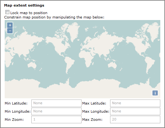
You can use the ![]() Map extent settings to restrict the users ability to change the map view.
Map extent settings to restrict the users ability to change the map view.
| Option | Description |
|---|---|
| Lock map to position |
Disables the zoom and click-and-drag capability. |
| Min Latitude |
These values define the minimum zoom view. Zoom in on the map in this dialog box until the preview shows the maximum view that you want users to see. This automatically sets the minimum and maximum values for Latitude and Longitude and minimum Zoom. Alternatively, these values can be set manually. |
| Min Longitude | |
| Min Zoom | |
| Max Latitude | |
| Max Longitude | |
| Max Zoom | Defines the maximum zoom. |
You can use the Click Action settings to add, edit, or remove click actions.
The Layer Settings page has links to More settings at the bottom of the page. Options vary, depending on the map type.
| Option | Description |
|---|---|
| Visible |
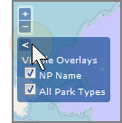
Displays the data layer on the portlet by default. Clear the check box to hide the data layer. NOTE: Users can be override this setting by clicking the Visible Overlays |
| Layer Opacity | Specifies the layer opaqueness. The default is 0.5. |
| Min Zoom | Defines the zoom level above which the data layer appears. |
| Max Zoom | Defines the zoom level below which the data layer appears. |
Applies to DivePort 7.0(19) and later point maps
| Option | Description |
|---|---|
| Enable data polling | Updates the portlet data at a specified interval. |
| Data polling interval | Defines the interval, in seconds at which the portlet data updates. |
Applies to boundary, heat, hexbin, and point maps. Available options depend on the type of color scale:
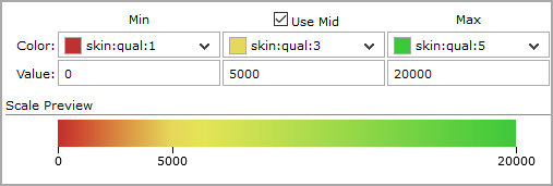
Gradient
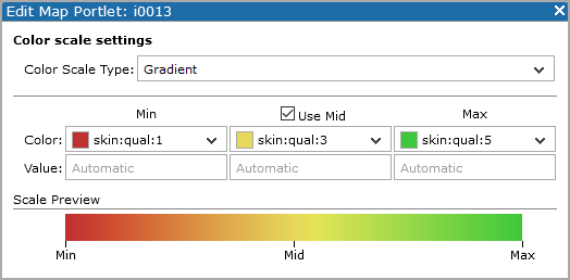
This is the default color scale type for heat maps.
| Option | Description |
|---|---|
| Color Scale Type | Gradient |
| Use Mid | Includes the middle value on the legend. |
| Color | Specifies the map colors used for the minimum value, middle value, and maximum value. |
| Value |
Specifies the data values for the range of the color scale. The default Automatic uses the range of specified data values. NOTE: The Mid value does not have to be the exact center of the range.
|
Threshold
Threshold maps show if an area meets, exceeds, or fails to meet specified metrics. Threshold settings define the metric values and colors for each zone.
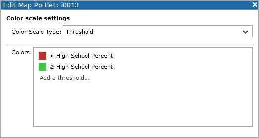
Click Add a threshold to open the Threshold settings page where you can select a Threshold and color.
NOTE: Map threshold settings are similar to indicator threshold settings. For more information, see About Indicator Thresholds.
Binned
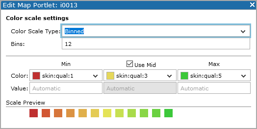
This is the default color scale type for boundary, hexbin, line, and point maps.
| Option | Description |
|---|---|
| Color Scale Type | Binned |
| Bins | Specifies the number of bins (colors) on the map. |
| Use Mid | Includes the mid point value on the legend. |
| Color | Specifies the map colors used for the minimum value, midpoint value, and maximum value. |
| Value |
Specifies the data values for the high and low end of the color scale. The default Automatic uses the range of specified data values. |
Applies to boundary, hexbin, and point maps. Use to add or customize the ![]() labels that appear on the map.
labels that appear on the map.
| Option | Description |
|---|---|
| Show legend | Specifies that a legend is included on the map. |
| Summary Format | Defines the format of the legend numbers. Specifies the format for the numeric data that appears in the legend. The default, Automatic, |
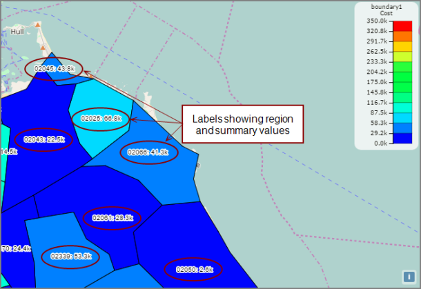
| Display region in label | Applies to boundary maps only. Adds the region location value to the map. |
| Display summary in label | Applies to boundary and hexbin maps. Adds the numeric data to the map. |
| Alternate Region Label |
Specifies a column and display its value in place of the region value. This value also appears as a
|
| Min Zoom Level for Display | Applies to boundary maps only. Specifies the zoom level at which the data labels appear. When a user zooms in or out, the label layer displays when the current zoom level is greater than or equal to this setting. The default is 2. |
| Label Font | Applies to hexbin maps with Display summary in label selected. Specifies the hexagon label font and color. |
Applies to point maps only. Use to customize the appearance of points.
| Option | Description |
|---|---|
| Point Size | Sets the data points to a constant size in pixels or scales the point size based on a scale from a specified data column. The default is 5 px. |
| Min Size | Applies when the point size is set to a data column. Specifies the smallest size used for data points. The default is 2 pixels. |
| Max Size | Applies when the point size is set to a data column. Specifies the largest size used for data points. The default is 10 pixels. |
| Point Opacity | Specifies the opaqueness of the data points. The default is 0.9. Lower numbers are more transparent. Alternatively you can specify a data column to scale the point opaqueness based on a scale from that column. |
| Enable data points animation | Applies to maps with data polling enabled and a second set of longlat coordinates specified. When the map polling interval occurs, DivePort uses animation to refresh the map data. |
| Destinations |
Specifies the longlat coordinates for the destination location. NOTE: If this value matches the Location set on the Layer settings page, the update is not animated. |
Applies to hexbin maps only. Use to customize the appearance of the hexagons.
| Option | Description |
|---|---|
|
Hex Lattice Size (px) |
Specifies the size of the hexagon grid, which is used to assign map coordinates into hex bins. For example, setting the hex lattice size to 30 bins data into hexagons assuming the hexagons have a 30 pixel radius. The default value is 20 pixels. NOTE: Hex lattice size can be different from the actual hex size. |
| Hex Size (px or column) |
Specifies the size of the hexagons that appear on the map.
The default value is 20 px. |
| Min Size (px) | Available when the Hex Size is a column value. Specifies the minimum pixel radius for a hexagon. The default value is 2 px. |
| Max Size (px) | Available when the Hex Size is a column value. Specifies the maximum pixel radius for a hexagon. The default value is 20 px. |
If you use Unicode characters, be sure to use the proper encoding and standards.
TIP: When developing HTML content, consider using a text editor or a web design tool to write the code, and then use a copy and paste operation to insert the text into the Contents of hover box dialog box.
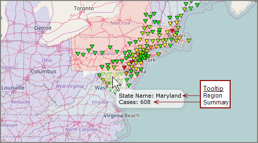
Leave the box blank for the default behavior, which is to display the location and value summary data.
You cannot include links or other click actions in the tooltip.